
If the Detention Pond Meets the Rules, Why Is My Neighborhood Still Flooding?
STORMWATER
Travis Basnett, PE · Licensed in SC, NC & GA · October 6, 2026 · 10-minute read
New development and downstream flooding are often discussed as though either the residents or the engineer must be wrong. Stormwater is more complicated than that.
“It never flooded until they built that subdivision.”
It is one of the most common complaints you hear after new development occurs upstream.
Residents point toward the new houses and the water they can see in their yards. The developer points toward an approved stormwater design. The engineer can show that the detention pond was designed to meet the applicable requirements.
It feels like one of those statements has to be wrong.
But a development can meet its stormwater requirements while flooding can still occur downstream. Understanding how those facts can coexist starts with a surprisingly simple distinction: how fast water arrives is not the same thing as how much water arrives.
Empty five gallons of water into a sink as fast as you can and the sink may overflow. Pour the same five gallons slowly over twenty minutes and it may handle the water without a problem.
The volume did not change. The flowrate did. The same distinction appears in Why a 1-Hour Thunderstorm Can Cause More Flooding in Columbia Than a Day of Rain.
That distinction is at the heart of how most detention ponds work, and it is also where many conversations about development and downstream flooding begin to go past each other.
Flowrate is not the same thing as volume
Engineers generally describe stormwater using several different measurements, but two are especially important here.
Flowrate describes how quickly water is passing a particular point. Engineers commonly measure it in cubic feet per second (cfs).
Volume describes how much water passes that point over the entire storm.
Before land is developed, rainfall has several places to go. Some runs across the surface, some soaks into the soil, some collects in small depressions, and some is intercepted by vegetation or eventually returned to the atmosphere.
Development changes that balance.
Roofs, pavement, sidewalks and compacted ground generally cause more rainfall to become runoff. Pipes, gutters and drainage systems also collect that runoff and move it more efficiently.
Without stormwater controls, development can therefore change both how much runoff leaves a property and how quickly it gets there.
That is one of the primary reasons detention ponds are used.
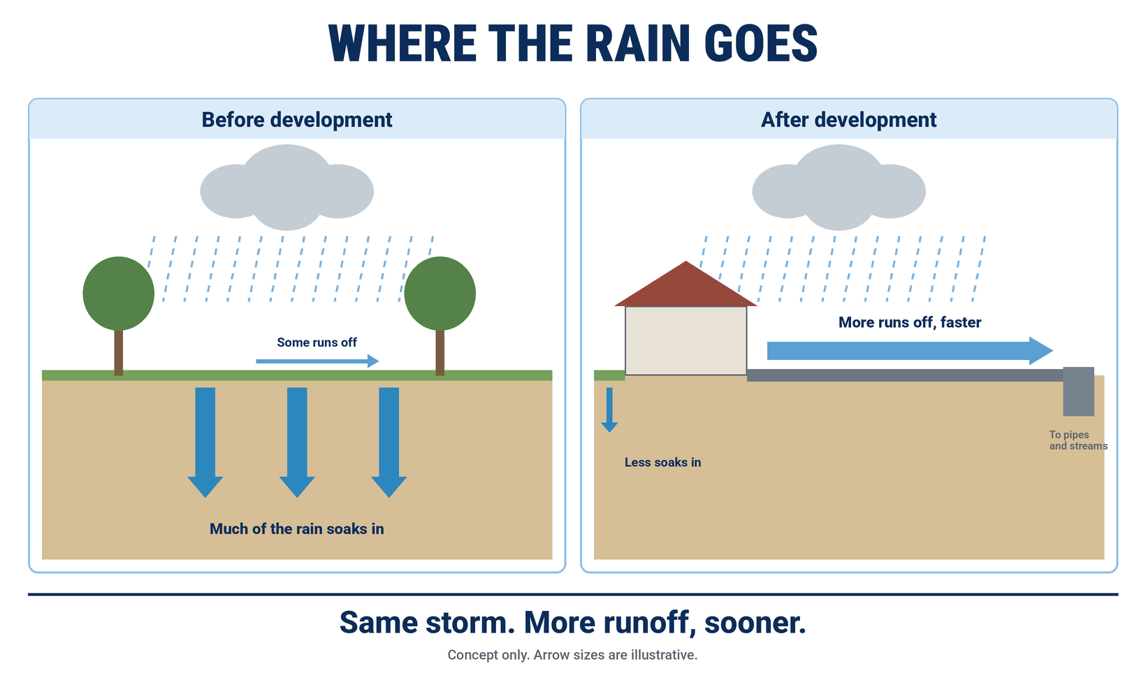
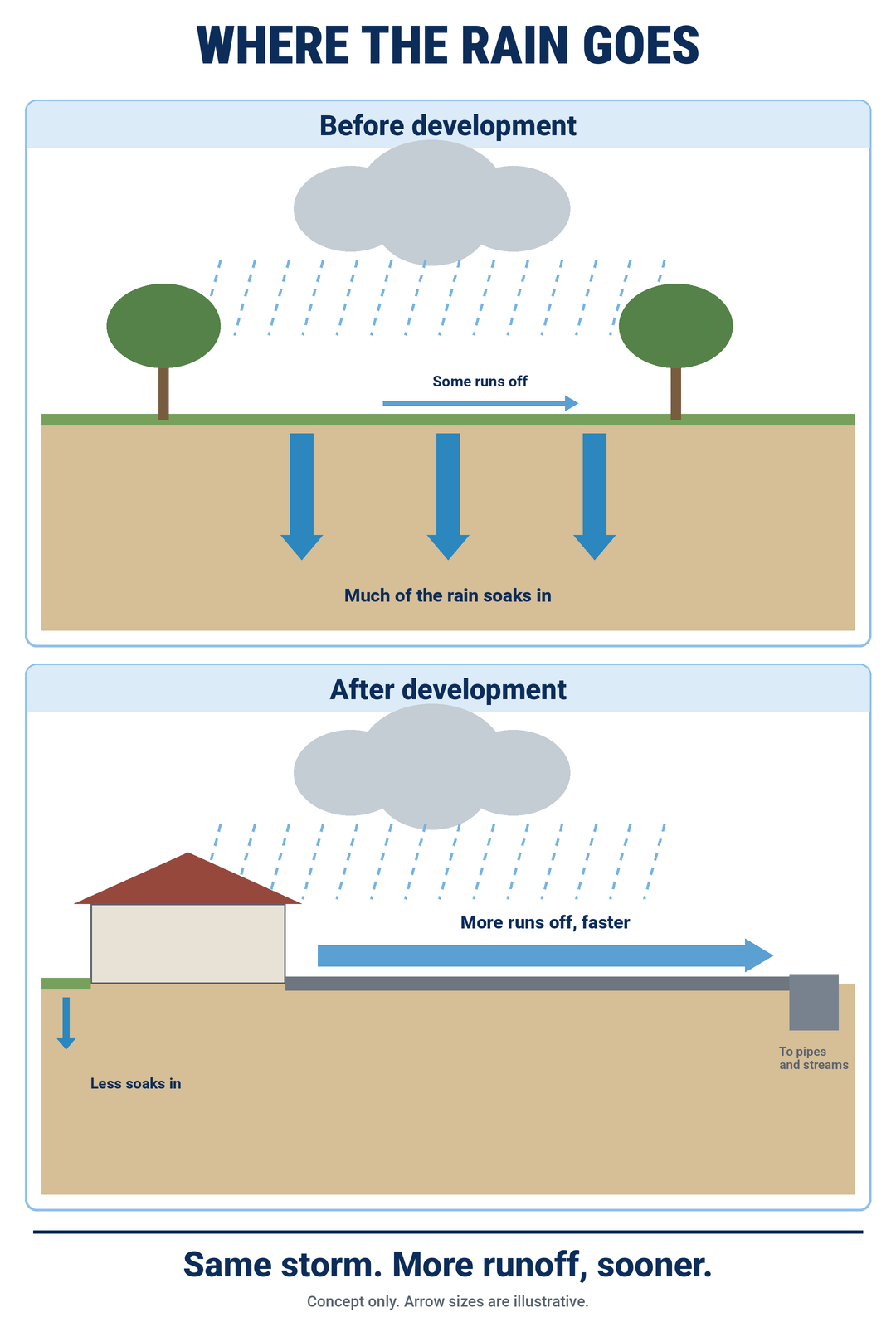
Figure 1. Where the rain goes before and after development. Conceptual illustration.
What a detention pond actually does
A conventional detention pond is essentially temporary storage.
During a storm, runoff enters the pond faster than the outlet allows it to leave. Water accumulates temporarily and is then released gradually through an outlet structure.
The pond therefore changes the timing of runoff.
Without detention, a developed site might release a relatively high flow over a short period. With detention, some of that runoff can be stored and released over a longer period, reducing the peak discharge rate.
But unless water is infiltrated, reused, evaporated or otherwise removed from the runoff system, detention does not make that water disappear.
Depending on the site and the stormwater practices used, a development may therefore meet its required peak discharge rate while still producing a greater total runoff volume than the pre-development condition.
Engineers often illustrate this with a hydrograph, which is simply a graph showing flow over time.
After development, an uncontrolled hydrograph will often become taller and occur earlier. A detention pond can lower and delay that peak by releasing the runoff over a longer period.
That longer release also means downstream channels may experience elevated flows for a longer duration. Depending on the receiving system and the storms involved, duration can matter for channel erosion and for how much storage or conveyance capacity remains available if another storm follows closely behind.
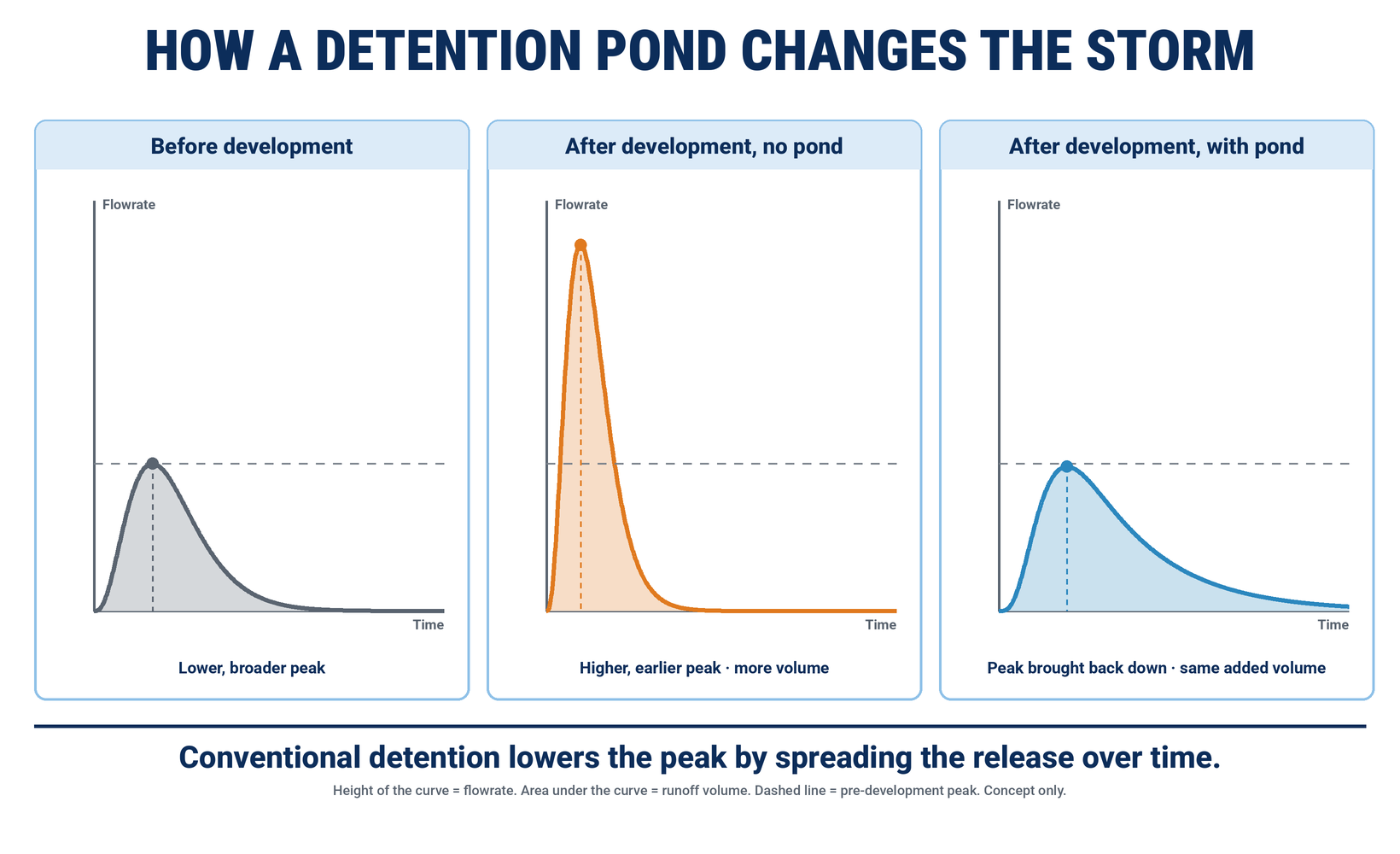
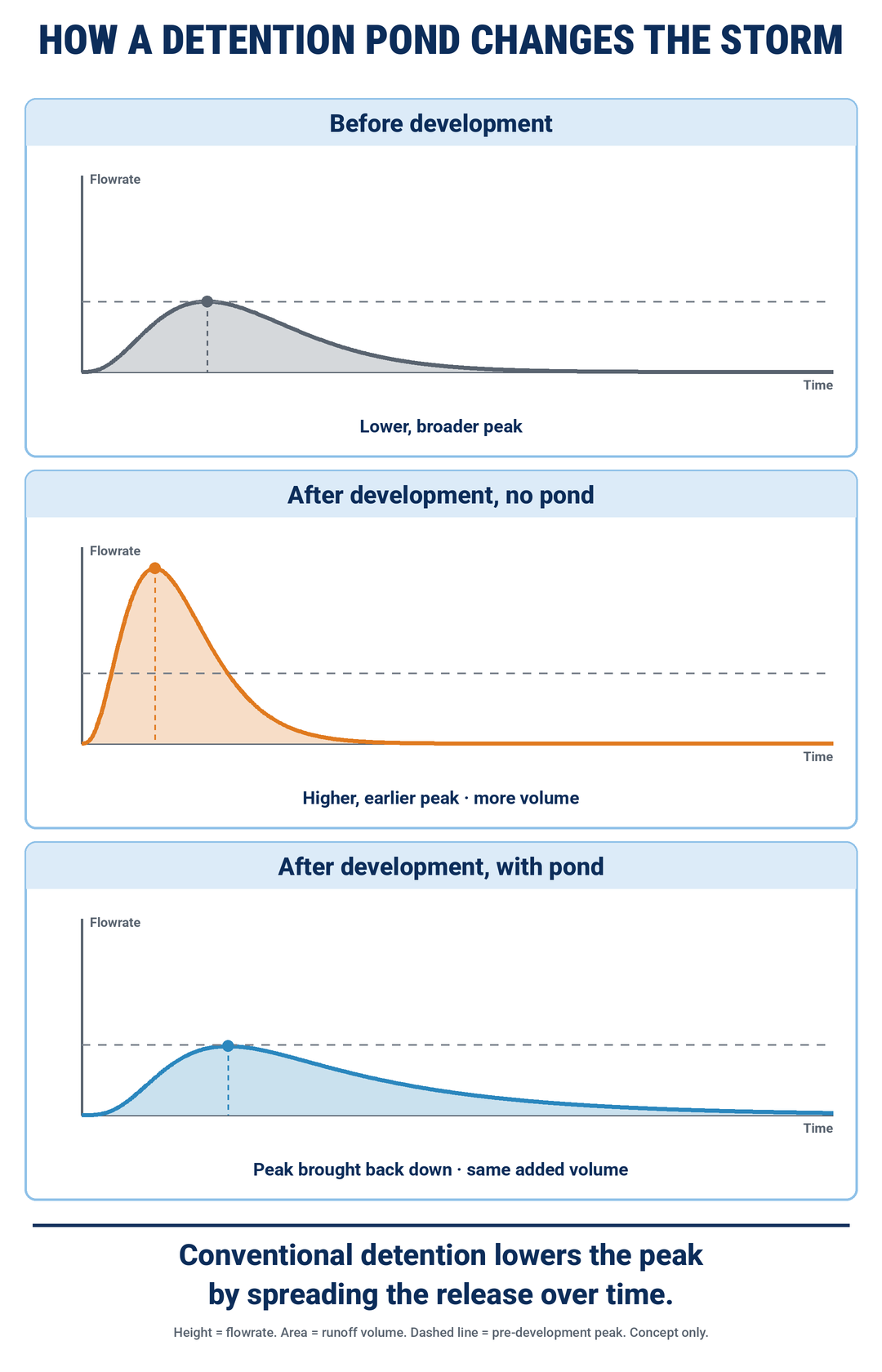
Figure 2. Conventional detention lowers the peak by spreading the release over time. The curves are conceptual, not site-specific predictions.
The basic point is straightforward: controlling the highest flowrate is not necessarily the same thing as controlling the total runoff volume or the length of time that elevated flow occurs.
What are engineers actually designing for?
Stormwater facilities are not designed for an unlimited amount of rainfall.
Engineers evaluate sites using specified design storms, such as storms associated with 2-year, 10-year, 25-year or 100-year recurrence intervals.
The terminology can be misleading. A “100-year storm” does not mean that such a storm can occur only once every 100 years. It describes an event with approximately a 1 percent chance of being equaled or exceeded in any particular year. For a broader explanation of how stormwater moves through a drainage system, see What Happens When It Rains?.
In South Carolina, the statewide minimum stormwater criteria generally require post-development peak discharge rates not to exceed pre-development rates for the 2-year and 10-year, 24-hour storms. The regulations also allow implementing agencies to use less frequent events, such as the 25-year storm, when warranted by local stormwater conditions.
Local requirements may go beyond those statewide minimums.
Different parts of a stormwater system may also serve different purposes. The normal outlet may regulate selected design storms while an emergency spillway provides a safe path for larger flows.
Seeing water move through an emergency spillway during an exceptional storm therefore does not, by itself, establish that the pond failed or was under-designed. The relevant questions include what event occurred, what the facility was designed to handle and whether the facility performed as intended.
Engineering provides a design level of performance. It does not establish an upper limit on how much rain can fall.
Detention is not the only way to manage runoff
Traditional detention primarily changes rate and timing.
Other stormwater practices can also reduce runoff volume.
Infiltration systems, bioretention areas, permeable pavement, preserved natural areas and some Low Impact Development practices are intended to keep more rainfall near where it fell. Some systems also capture stormwater for reuse.
Even familiar terms such as detention pond and retention pond can become confusing because terminology and design details vary. A pond containing a permanent pool of water, for example, can still discharge substantial runoff during a storm.
For this discussion, the more useful question is simply:
Does the stormwater system primarily delay runoff, or does it also reduce the amount that ultimately leaves the site?
Those are different functions, and many modern stormwater systems use some combination of both.
The pond is not the end of the water's journey
At a development site, an engineer can calculate the runoff entering a pond, the water temporarily stored there and the flow leaving through its outlet.
But the pond may be the end of the development's stormwater system. It is not the end of the water's journey.
From there, runoff may enter a ditch, pipe, creek or river and combine with runoff from other parts of the watershed.
That larger watershed may contain older subdivisions, commercial properties, roads, undeveloped land, other detention ponds, culverts, bridges and floodplains. Some of those features may have been built decades apart under different standards.
And they do not all respond to rainfall at the same time.
Imagine two tributaries entering the same creek. Under one condition, runoff from the first tributary peaks at 2:00 p.m. while runoff from the second peaks at 4:00 p.m. Their highest flows therefore do not arrive downstream simultaneously.
Now suppose detention within the first tributary lowers its peak but delays some of that runoff until later.
If that delayed flow overlaps more closely with runoff from the second tributary, the combined downstream hydrograph can change even though the individual detention facility reduced the peak flow leaving its own site.
That does not mean detention ponds inherently worsen flooding. It means watershed behavior depends on where runoff originates, how much runoff is produced and when those different flows arrive downstream.
A single peak-flow calculation at one property does not describe all of those interactions on its own.
South Carolina’s regulations recognize this issue: where ponds are proposed, the approving agency can require downstream analysis of the 10- and 100-year storms, including how the pond changes hydrograph timing. The relevant question is therefore what downstream analysis was required and performed for the particular project.
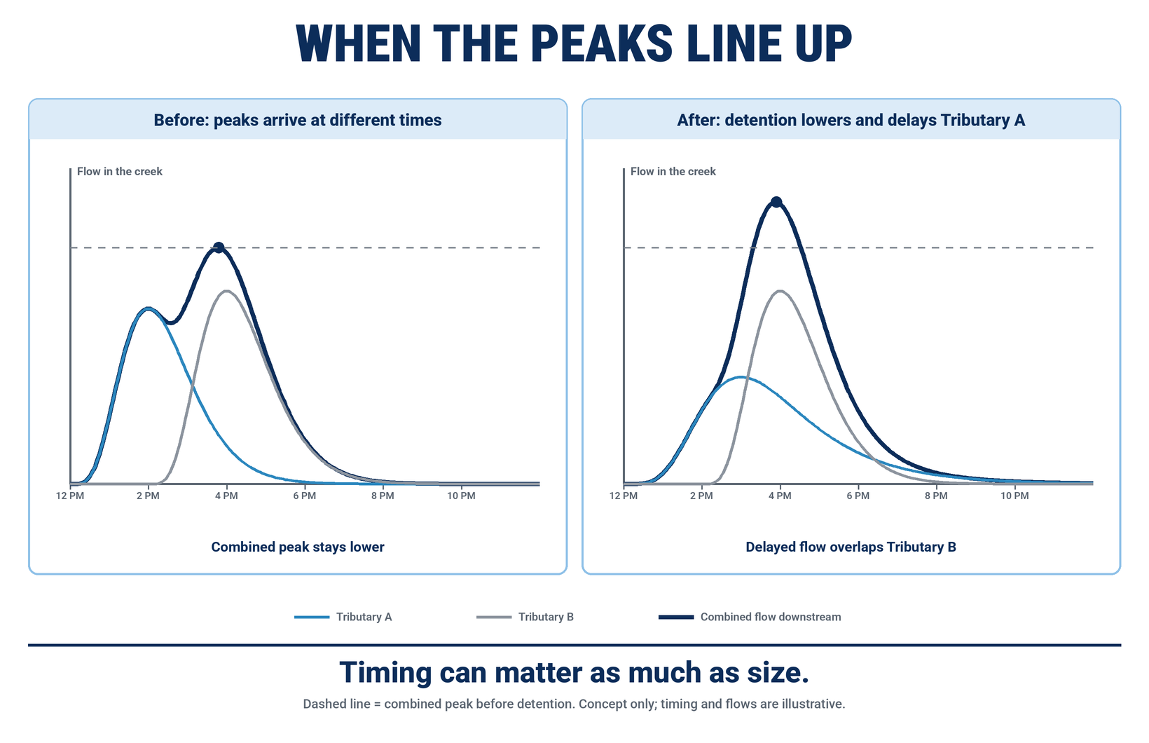
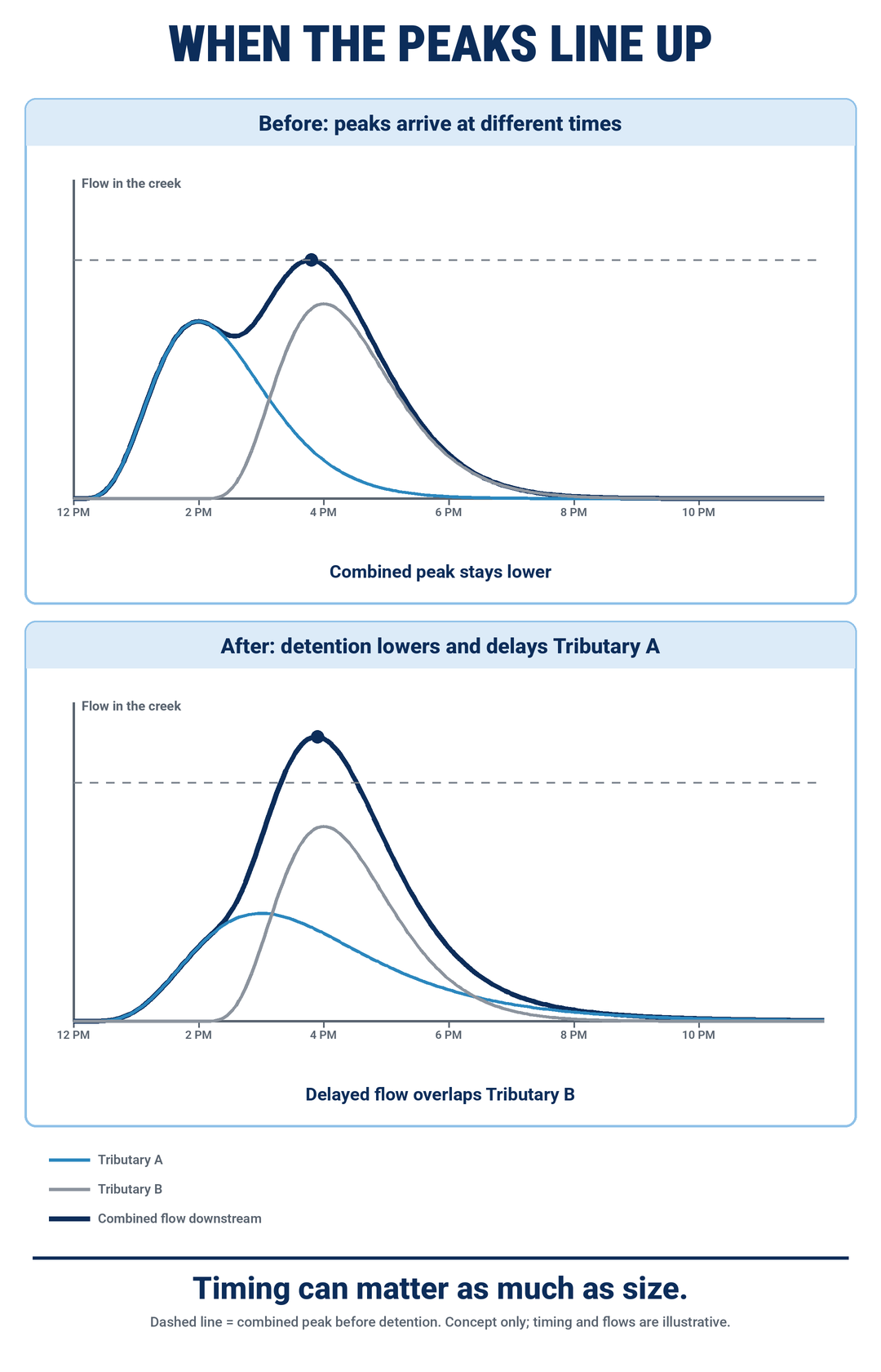
Figure 3. An illustrative change in tributary timing and combined downstream flow. Conceptual illustration, not a conclusion about a particular watershed.
Why regulate site by site, and what does that miss?
There are good reasons stormwater regulation begins with individual development sites.
A project changes a particular property, so the regulatory framework generally requires that project to manage specified stormwater effects associated with that change.
That gives the developer a defined design standard, gives the engineer something measurable to calculate and gives the reviewing agency an objective criterion to evaluate.
It also prevents new development from simply allowing uncontrolled increases in runoff rates to pass downstream.
The limitation is one of scale.
A site-level analysis asks what happens because of a particular project. A watershed analysis asks what happens when runoff from many properties, drainage systems and natural features eventually comes together.
Neither question makes the other unnecessary.
Consider a watershed that already contains an undersized road crossing, older development built before modern stormwater requirements, reduced floodplain storage and a channel with limited capacity. A new development proposed upstream enters a system that already has a history.
The regulatory process must evaluate the proposed project's effects, but the existence of a preexisting watershed problem does not mean that the newest property created the entire problem.
This is also why “just model the whole watershed” is not as simple as it sounds.
A watershed model requires decisions about where the model begins and ends, existing versus future land use, rainfall assumptions, drainage infrastructure, calibration, responsibility for updates and how preexisting deficiencies are treated.
The cost and effort can also be very different for a small project than for a major development.
Watershed analysis can provide valuable information about the physical system. Deciding how responsibility for regional problems is allocated among new development, existing development and public infrastructure is ultimately a policy question in addition to an engineering one.
The system on paper and the system in the ground
There is another possibility whenever actual conditions appear different from the expected design performance: the facility in the field may not be operating exactly as modeled.
An outlet can become blocked. Sediment can reduce available storage. Debris or vegetation can obstruct structures. Erosion can alter channels.
South Carolina's stormwater regulations require preventive maintenance and inspections of completed stormwater practices because continued performance depends on the facilities remaining functional.
Active construction also creates temporary conditions that differ from both the original site and the completed development. Large areas of disturbed soil can produce sediment that must be managed by construction-phase erosion and sediment controls.
So when a drainage problem appears downstream, several different questions may be relevant.
Was the facility designed to the applicable criteria? Was it built according to that design? Has it been maintained? What rainfall actually occurred? Have conditions changed elsewhere in the watershed?
Those questions are more useful than simply asking whether the pond “works.”
“It never flooded until they built that subdivision.”
That observation is a reasonable reason to investigate.
But the sequence of two events does not, by itself, establish causation.
Flooding can be influenced by rainfall intensity and duration, upstream development, downstream obstructions, culvert capacity, channel condition, maintenance, floodplain changes and cumulative changes throughout the watershed.
The opposite conclusion can also go too far:
“The development was permitted, so it could not have affected downstream conditions.”
A permit shows that a project was designed and reviewed against the applicable rules. It does not settle whether that project affected a particular flood, and flooding after development does not prove that it did. Answering that question takes the specific site, storm and watershed.
Where does that leave us?
Stormwater regulations address a real consequence of development by requiring runoff to be managed rather than simply passed downstream uncontrolled.
But an individual development and the watershed containing it are different scales of the same physical system.
Understanding the difference between rate, volume and timing helps explain why a compliant stormwater design and a downstream flooding complaint are not automatically contradictory.
And that is a much better place to begin the conversation than assuming either one tells us what happened.
Sources
South Carolina Department of Environmental Services, Standards for Stormwater Management and Sediment Reduction, S.C. Code Ann. Regs. 72-300 through 72-316, including 72-307(C)(4)(a), 72-307(C)(6), 72-307(I)(3)(h) and 72-308(B)–(D): statewide design criteria and maintenance requirements.
